Posts

Showing posts with the label New River Gorge

Hiking the Waterfalls of Big Branch

Image
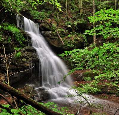
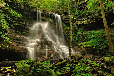
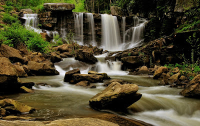
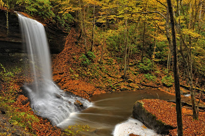
If you like waterfalls, you�ll love the Big Branch Trail of the New River Gorge. Depending upon how you count them, you�ll see six or seven waterfalls in the space of � mile. For the sheer joy of seeing water descend over rock, the Big Branch Trail is hard to beat. I won�t describe all the waterfalls in this blog, but we�ll take a look at most of them. Big Branch Falls Trailhead The trailhead is about 4 miles from Hinton on the River Road�the road that takes you to Sandstone Falls. Look for the trailhead across the road from the Brooks Falls overlook. Starting at the trailhead, take the left-hand fork, which after about 500 feet of woodland walking leads to the streambed of Big Branch. At this point the trail crosses Big Branch for the first of four times. Since this stream doesn�t have a large watershed, it�s generally a trickle in summer and fall. But in winter and spring, it�s full enough that you should plan to get your boots wet when crossing. First Waterfall First Waterfall Befo...

More Adventure from my book �Exploring the Wilds of West Virginia�: Wolf Creek Falls

Image
Wolf Creek is well named. It�s wild, intimidating, and untamed. It charges down the slopes of the New River Gorge like a wild animal. Not surprisingly, Wolf Creek Falls are rough and rugged, too. Fortunately, you don�t have to hike far to find them because they�re just off a paved road. But as if lying in wait, they are quite hidden from the road, and undoubtedly thousands of visitors to the gorge drive right by them unaware of the awesome waterfall just a few feet from them. Wolf Creek Falls Hidden Treasure To find this hidden treasure of the gorge, you�ll need to drive into the New River Gorge and back out again. Starting from the Canyon Rim Visitor Center at the north end of the New River Gorge Bridge turn right out of the parking lot and drive two-tenths of a mile. Make a very sharp right hand turn, and proceed downhill a tenth of a mile to a junction with the Fayette Station Road.  View from Fayette Station Bridge Fayette Station Road Fayette Station Road is a one-way, paved r...

The Wonder of White Oak Falls

Image
�As I approached White Oak Falls on my second visit, a shaft of light was shifting across the face of the falls. I had to work fast to get this shot. I scampered up the rocks and into the basin below White Oak Falls, hurriedly set up my tripod in the stream bed, and, while trying to keep my wits, started shooting as quickly as possible. You just never know what you're going to find when you take a walk in the woods with your camera. The world changes day-by-day, minute-by-minute. How exciting!� from West Virginia Waterfalls: The New River Gorge by Ed Rehbein and Randall Sanger. Click HERE.   White Oak Falls The Great Mystic White Oak Falls is the great mystic of southern West Virginia waterfalls. A beam of light seemingly sent from the heavens illuminates the falls adding a magical quality that few other waterfalls possess. What�s more it happens regularly�usually mid to late afternoon. Photographs of this blade of light crossing the face of White Oak Falls create a uniquely moody...

Five Waterfalls of the New River Gorge

Image
Nestled in the steep slopes of the New River Gorge are hundreds of rugged waterfalls. These waterfalls are fertile ground for nature lovers offering challenging hikes and striking landscapes. Having published a photo book of the waterfalls of the New River Gorge, I�d like to share five of those waterfalls that really stand out.  Cathedral Falls Let�s start with picturesque Cathedral Falls, which is located on US Highway 60 one mile east of Gauley Bridge, WV. Since the falls are located at a roadside rest stop, access is easy. You can literally step out of your vehicle and start photographing the falls. Descending 60 feet in a series of three dramatic drops within a large semi-circular rock amphitheater, Cathedral Falls is as photogenic as they come. Easy access generally means plenty of visitors and photographers, so you have to be patient and creative to get a photograph. To eliminate people in the foreground, I generally work my way around the left side of the rock amphitheater f...

New River Gorge Waterfalls: Award Winning Photography Book

Image
What others are saying about West Virginia Waterfalls: The New River Gorge by Ed Rehbein and Randall Sanger.  �More than 100 waterfalls grace the cliffs and canyons of the New River Gorge and its tributaries. This book invites you the savor this untapped wealth of beauty in two enjoyable ways�by viewing photographs of these waterfalls and by experiencing them for yourself.  Laurel Creek Falls �Photographers, hikers, and nature lovers Ed Rehbein and Randall Sanger have photographed some of the most beautiful places in the New River Gorge, plus�provided maps and information on how to visit each waterfall yourself. The pull-out hiking guide will keep you on the path to your own Appalachian Adventures.� Book Cover Pirate's Cove �The New River Gorge is such a beautiful place that it is often said photos don't do it justice. This photography certainly does. Ed Rehbein and Randy Sanger have successfully captured not only the beauty of these waterfalls, but the emotion and the majesty...

The Seven Wonders of West Virginia

Image
The world has its seven wonders. So why not West Virginia? After all the State is called �Wild, Wonderful West Virginia,� and rightly so. West Virginia, The Mountain State, abounds in scenic wonders. Nestled among more urban and populated eastern states, West Virginia is an island of mountains, forests, rivers, and plateaus. Indeed, choosing just seven natural wonders to highlight proved daunting. But subjective as it is, from north to south here is my list:  1. Dolly Sods 2. Canaan Valley 3. Seneca Rocks 4. The Cranberry Glades  5. The Falls of Hills Creek 6. The New River Gorge  7. Sandstone Falls Dolly Sods Credentials of the Seven To make the list, the seven wonders had to fit certain criteria. For instance, they all had to be well-known landmarks, if not nationally, certainly state-wide. They had to be �on the map,� that is, located and identified on a West Virginia State Highway Map. Furthermore, I felt the north, central and southern regions of West Virginia all ha...

Ramsey Branch Falls: a Hidden Gem

Image
Ramsey Branch Road is rough and rocky, but worth the ride. It drops you off at a secluded and lovely place--Ramsey Branch Falls. Nestled in a canyon just off the Gauley River, the falls are truly a gem hidden in the hills of the New River Region.   Ramsey Branch Falls To get to Ramsey Branch Falls take U.S. 60 five miles west of its intersection with U.S. 19 to Saturday Road (GPS: Lat. 38.128491, Long. -81.074095). Turn right (north) on Saturday Road and wind through the countryside of pastures and woods. After 6.9 miles turn left at the junction with Ramsey Branch Road and continue 1.6 miles to the Gauley River. The last half a mile is steep, rough, rocky, and requires a truck for 4WD vehicle with a high center.  Ramsey Branch Falls Turn right at the river and after a very short distance look for a road to the right which drops down to the streambed of Ramsey Branch. Take this road for just a few yards and stop at a hairpin turn at creek level. A short, bushwhacked trail lead...

Exploring the Endless Wall Trail to Diamond Point and Beyond

Image
The Endless Wall Trail was voted the #1 National Park Trail by readers of USA Today ( Endless Wall Trail ). And for good reasons. Many stunning vistas of the New River Gorge line the trail. In this post I will highlight the best overlooks and other points of interest in a 2.6 mile loop trail of the Endless Wall. Endless Wall from Diamond Point Start at the Fern Creek Parking Area (GPS: Lat. 38.06298, Long. -81.05682) on the Lansing-Edmond Road (County Road 82) just 1.3 miles from its intersection with U.S. 19. The Endless Wall Trail begins by meandering on a flat, well graveled path through a lovely hemlock forest. After a half-mile, it crosses Fern Creek and begins a gradual ascent through a rhododendron thicket. As the trail tops the hill, the Fern Buttress Overlook takes off to the right at the 2/3 mile mark. The vistas are somewhat obscured by trees, but the viewpoint still gives you a sense of the depth of the gorge. On the right (north) side of Fern Buttress, paths zigzag to the ...

Brush Creek Falls Trail: Short Hike to a Tall Waterfall

Image
My jaw dropped the first time I saw Brush Creek Falls. I couldn�t believe such a lovely, large, and accessible waterfall had escaped my attention for so long. The falls span the width of Brush Creek and are about 33 feet high. A few smaller drops precede the main fall. The Brush Creek watershed is substantial and supports good flow in summer. While it begins as a shallow, meandering stream, Brush Creek swells to river size and cuts a 400-foot deep canyon by the time it reaches the falls.  Brush Creek Falls Twenty-four acres surrounding Brush Creek Falls are now managed by the State of West Virginia as part of Pipestem Resort State Park. To get to Brush Creek Falls from the Pipestem State Park entrance, take state Route 20 south 4.5 miles to the town of Speedway and turn right onto county Route 3 (Brush Creek Falls Road, GPS: Lat. 37.45632, Long. -81.01005). After 2.7 miles bear left on county Route 3 and descend 0.6 miles into the Brush Creek Gorge. Park at the picnic shelter just ...