Posts

Showing posts from September, 2016

Three Tips for Better Fall Photographs

Image
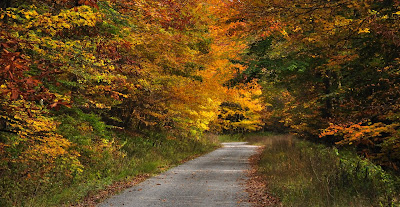
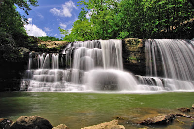
Though digital cameras are technologically impressive, none of them can capture a scene as well as the human eye and mind working together. Aware of the limitations of their technology, camera manufacturers have added features to compensate for them. In this article, I offer three tips on how to use these features to improve the photography of the brilliant colors of fall. To illustrate my tips I will refer to a photograph I took in the Fall of 2012 at the New River Drys.    Briery Knob Tip #1: Experiment with the White Balance.  White balance settings on your camera compensate for the kind of light illuminating the scene you are shooting. As evidenced by the color of the sky, a sunny day sheds a lot of blue light. Your eye working with your mind automatically tones down the excess of blue light in such a way that a white object will still appear white to the eye. But a camera does not do this. It simply records without bias the colors of light hitting its sensor.  Example Photo If you

Germany Valley Overlook Cabins

Image
Germany Valley Overlook Cabins�the name says it all. The views are spectacular. Softly lit morning skies, dazzling afternoons, and stunning sunsets, come standard with each cabin. Nestled in the mountains of Pendleton County near Franklin, West Virginia, Germany Valley Overlook Cabins offer a distinctive lodging experience.  Germany Valley from North Fork Mtn Lovingly built in 2005 and 2006 by owners and operators Bill and Luci Raines, each cabin has a unique floor plan. Cabins 1 through 3 are log cabins with vaulted ceilings, wood interiors, and hardwood floors. Cabin 1 was assembled with logs from a neighbor�s small sawmill. The Raines designed and built this cabin inside and out from plans Luci sketched on graph paper. As the smallest cabin, its 900 square feet sleeps a maximum of six. With 1400 square feet, Cabin 2 is the largest cabin sleeping a maximum of nine. Cabin 2 features a cherry log staircase railing that the Raines hand-peeled from logs from their farm. The interior wall

Creating a Shinier World

Image
I could have been enjoying eating mooncakes at home. Instead, I decided to do a good deed with my fellow NYP volunteers, and I was glad I did just that! Project Clean-Up, which took place on 15th September, was an event organized by the Home Nursing Foundation (HNF). The objective of the exercise was to help the elderly patients who live independently but are physically unfit, and unable to manage their household chores. HNF delivers comprehensive care programmes dedicated to patients who require emotional, physical and medical support at their homes. It often organises community events to look after the social welfare of patients and beyond nursing or medical care. In July this year, I too had the opportunity to participate in the Community Awareness Carnival organized by HNF as a volunteer helper.  So when I heard about this new project by HNF, I promptly signed up. Besides volunteers from NYP, there were also volunteers from Bayer, a Life Sciences company that focuses on pharmaceuti

From Mechatronics Amateurs to Medallists

Image
Eljer (left) and Clarence (right) Worldskills Singapore, is a nation-wide skills competition for Singaporean youths who excel in a wide range of skills such as CNC milling, mobile robotics and web design. This year, the finals was held from 7 to 9 July 2016 at ITE Central and ITE College West. We saw students from the five polytechnics and ITE participating in the finals. I decided to interview two outstanding students from NYP who won the gold medal in the Mechatronics skill area. The duo, Clarence Lim and Eljer Chua are final year students from the Diploma in Mechatronics Engineering. Their exceptional talent in Mechatronics have not only won them gold medals in Singapore, they were also selected to represent Singapore in the international-level WorldSkills Competition in Abu Dhabi next year! The Mechatronics skill area requires competitors to solve logic problems, assemble a machine according to documentation, programme a machine, interpret technical documentation, and design electr

Where to Go for Early Autumn Color in WV

Image
Every year anticipation builds as fall approaches. Autumns can be glorious in West Virginia as leaves turn from green to gold. And every year we wonder what kind of a year will it be for color. Although much is known about why leaves change color, every year is different. So it�s difficult to predict how vivid the colors will be and what the timing will be. But here are some rules of thumb for where to best appreciate the first colors of autumn in West Virginia. Highland Scenic Highway - 2012 Highland Scenic Highway Leaves first start changing color at high elevation, so it�s best to start in the highlands. Although it varies yearly, fall foliage colors generally peak at high elevations in the last week of September to the first week in October. The Highland Scenic Highway (SR 150) is generally radiant with fall colors at that time of year. The Highway runs along the spine of the Allegheny Highlands in Pocahontas County, reaching more than 4,500 feet in elevation on Black Mountain. I l

An Eye in the Sky:Hanging Rock Raptor Observatory

Image
If you like mountaintop panoramas and vistas packed with receding ridgelines, you�ll love the Hanging Rock Raptor Observatory (HRRO) in Monroe County. Perched atop of Peters Mountain on the Eastern Continental Divide, the HRRO has a 360 degree unobstructed view of the mountains and valleys of southern West Virginia and Virginia. Fifty miles to the east, the Peaks of Otter on the Blue Ridge Parkway are visible. Looking north, Cold Knob and the Beech Ridge Wind Farm in Greenbrier County, though 40 miles distant, are clearly seen. And the verdant valleys of Sweet Springs and Potts Creek stretch out for miles on either flank of Peters Mountain.  Hanging Rock Raptor Observatory   Though the views are truly telescopic, there�s more to see at Hanging Rock. It�s a raptor observatory after all. �The 52-mile long mountain, among the longest in the Appalachians, helps produce thermal air currents that give migrating birds the lift needed to glide across vast segments of land while expending small

Adventures for Hikers on the Gauley River: A Tunnel, a Trestle, and a Waterfall

Image
Adventures for Gauley River hikers don�t end at Laurel Creek Falls. Much more excitement lies ahead. Continuing 0.2 miles down the road takes you to the shores of the Gauley River and an abandoned railroad grade running along its banks. The Laurel Creek road provides access to the Gauley River for whitewater rafters. There�s ample parking at the base of the road and a large set of stairs for rafters and their rafts to reach the shores of the Gauley.  Peters Creek Falls The Tunnel The Tunnel The abandoned road bed is a remnant of a twenty-eight mile stretch of railway built by the NF&G (Nicholas, Fayette and Greenbrier Railroad Company) in 1929 to 1931 to connect the towns of Swiss and Nallen. Hiking this old railroad bed is an easy way to explore and appreciate many miles of the Gauley River. Two tunnels were built for this railroad�one about a mile upstream from Carnifex Ferry near the Confluence Resort, and the other is less than half a mile from the parking area at Laurel Creek.

Adventures on the Gauley River That Don�t Require a Raft

Image
If you�re up for walking a perfectly straight line in nearly perfect darkness for 2/3 of a mile, if you�re ready to walk across the Gauley River from 60 feet above its surface, if you�re able to scramble down to a little known waterfall with a good 40 foot-drop, then you�re ready for some adventures on the Gauley that don�t require a raft. Gauley River at Laurel Creek Let�s start with Laurel Creek falls. But first, a word of advice. I would not take the family sedan on this safari. Though the base is firm, the gravel road to the Gauley River has some mud holes, rocky high spots, and is very steep at the end. An SUV or four-wheel drive truck is much better suited for this road. To find Laurel Creek Falls, from the intersection of US 19 and US 60, take US 60 4.6 miles west to Saturday Road (GPS: Lat. 38.12846, Long. -81.07408). From Hawks Nest Lodge, go east on US 60 for 3.25 miles. Saturday Road is a paved road that weaves through some lovely pastures and forests. After 6.4 miles, take