Posts

Showing posts from August, 2016

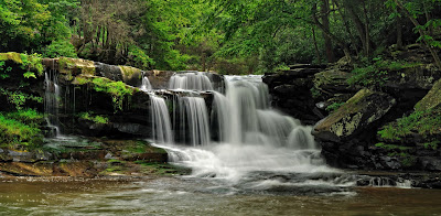
Pipestem Falls: Making a Come-Back

Image
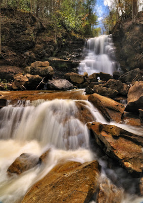
For 20 years, I drove within yards of beautiful Pipestem Falls, yet knew nothing of them. The falls weren�t on road maps or in tourist guides. The Internet provided scant information and very few photos. To add to the mystery, it was obvious that at one time these falls were a roadside attraction. A broad, grassed-over parking area, a weather-beaten picnic table, an overgrown trail, and a worn trailside fence mutely testified that Pipestem Falls was once a popular destination. Lower Pipestem Falls But that�s all changed now. The roadside parking has been improved; a road sign marks the falls, and brush obscuring the view of the main falls has been cleared. Pipestem Falls has made a come-back.  Lower Pipestem Falls To find Pipestem Falls (GPS: Lat. 37.5478, Long. -80.9596) drive 2.7 miles south of the Pipestem State Park entrance road on State Route 20. Look on the right for a broad, grassy area on the inside portion of a long curve. Parking is easiest at a wide, graveled patch at the d

America�s #1 Hike: The Endless Wall Trail

Image
What�s the best National Park day hike in America? It�s right here at home in West Virginia. In 2015, USA Today readers voted the �Endless Wall Trail� of the New River Gorge National River as the #1 National Park day hike. A panel of experts picked the initial 20 nominees, and the top 10 winners were determined by popular vote. The trail beat out prestigious contenders from other National Parks across the U.S such as Cadillac Mountain - Acadia National Park, Kilauea Iki Trail - Hawaii Volcanoes National Park, Hoh River Trail - Olympic National Park, Ramsey Cascades - Great Smoky Mountains National Park, The Narrows - Zion National Park, Bright Angel Trail - Grand Canyon National Park, Angels Landing - Zion National Park, Upper Geyser Basin - Yellowstone National Park, and Highline Trail - Glacier National Park. Wow, what a list!  View from Diamond Point Those of us in West Virginia know how beautiful our state is, but it�s quite an honor to be recognized by readers across the United St

Where are the Monarchs?

Image
Have you noticed that there are fewer monarch butterflies than in years past? If so, you�re not alone. According to researchers, in the last 20 years the population of monarch butterflies in the eastern U.S. has declined by 90 percent. When Phyllis and I first started exploring Canaan Valley and Dolly Sods, we could count on joyfully chasing and photographing large numbers of monarchs in fields of goldenrod and aster. But not lately. It�s a big loss.  Where are the monarchs? According to experts there are three main reasons for the monarchs decline: 1) Loss of breeding habitat in the Midwest, 2) Loss of wintering-over habitat in Mexico, and 3) Severe weather. The primary reason seems to be the decline in milkweed plants in the monarchs� breeding habitat in the Midwest. �The monarch cycles through 3-5 generations during the breeding season. Only the final generation migrates to Mexico. Monarch caterpillars feed exclusively on milkweed. Historically, the U.S. corn-belt has produced half

The Grass Bald: Dolly Sods

Image
In my mind one of the prettiest areas in Dolly Sods doesn�t have stunning rock outcrops or crimson colored heath like Bear Rocks. Don�t get me wrong. I love that part of the Sods. But I also love an area called the �Grass Bald.�  The Grass Bald is a sweeping terrain covered with grass and dotted with a few trees. The grass, known as mountain oat grass, has a subtle silver to white cast that is soothing to the eye. The grass is also called Allegheny fly-back due to the way the lightweight stems �fly back� from the scythe in mowing. Perhaps this is why the grass undulates so gently in the wind. Whatever the reason, the sight of this grass softly swaying in the breeze is mesmerizing.  Grass Bald on the Bear Rocks Trail The grass balds cover flat, drier areas of the Sods. No one is quite sure why trees don�t occupy the grass balds. Most think the areas were naturally open prior to logging. Thomas Lewis, a surveyor writing in 1746, reported such an area during his explorations. Some think t

Dunloup Creek Falls

Image
Just about everyone loves a waterfall. Fortunately in the New River Gorge, waterfalls abound. In our book West Virginia Waterfalls: The New River Gorge , Randall Sanger and I documented 120 waterfalls. And I know there are more. All waterfalls flow well in spring when there is plenty of water due to melting snow and thawing ground. But during the summer many streams shrink and waterfalls dry up. So in the summer where can you go in the New River Gorge to get your waterfall fix?  Dunloup Creek Falls One place is Dunloup Creek Falls (GPS: Lat. 37.9382, Long. -81.0977). It might need a little help from summer rains, but it has a sizable watershed that keeps the stream flowing even in summer. And it�s easy to find. From Glen Jean take the road to Thurmond. About 4 � miles from Glen Jean look for a wide pull off on the right hand side of the road where there�s parking for about three or four vehicles.  Dunloup Creek Falls The falls consist of a river wide drop of some 20 feet. Paths lead fr

Bear Rocks: Dolly Sods� Sculpture

Image
To me, the rocks that rim Dolly Sods have been sculpted into exquisite forms that resemble everything from humans and animals to abstract art. In a pamphlet about Dolly Sods published by the West Virginia University Extension Service, Norma Jean Venable wrote: �The boulders at Bear Rocks project from the stony earth as if placed by the hands of some ancient race of neolithic people.� This apparent element of intention or art in the rocks of Dolly Sods is intriguing and has led me to explain their origin in geologic terms.  Among the interesting shapes at Bear Rocks are rounded, often water-filled, depressions of varying diameters and depths carved into the stone. These depressions are called weathering pits or gnammas (nam uhs), the latter a term borrowed from the Aborigines of Australia, who depend on the water trapped in natural rock bowls for survival. A Large Gnamma at Dolly Sods Gnammas are formed by a geologic process called differential weathering. For example, should just a sli

Beauty Mountain in the New River Gorge

Image
The most beautiful mountain in the New River Gorge is appropriately named Beauty Mountain. I realize that of all the lovely mountains that grace our fair state picking one above the others is quite impossible. But to me Beauty Mountain is the fairest of them all. When folks from out of state visit me and are looking for the best scenery that the New River has to offer, I take them to Beauty Mountain first.  Beauty Mountain Looking Toward Diamond Point Why? It showcases the New River Gorge like no other place. Beauty Mountain isn�t really a mountain in the sense that it rises as a peak above the surrounding hills. Instead, Beauty Mountain is an unbroken stretch of sandstone cliffs running along the rim of the New River Gorge from Short Creek near Edmond, WV, to Keeney Creek. Nevertheless, the cliffs of Beauty Mountain tower more than 1000 feet above the New River. These lofty cliffs offer the best and most numerous overlooks of the New River Gorge of any place I�ve seen. What�s more the

Ride to the top of Canaan Valley: The Bald Knob Trail

Image
Where can you get the best panoramas of Canaan Valley?  The Bald Knob Trail in Canaan Valley Resort State Park is my first choice. From the top of Bald Knob you can get wide, sweeping views of the valley below.  View from Bald Knob To make it even better you don�t have to scale the mountain side on foot to get the view. Instead, the Bald Knob trail is unusual in that it begins after an exhilarating ride up the Canaan Valley Resort chairlift (GPS: Lat. 39.008589, Long. -79.437558). From the base at 3580 feet in elevation, the ride offers increasingly breathtaking views of the valley and surrounding mountains before ending at the mountain top at 4280 feet. That�s a boost of 700 vertical feet without taking a step!! Even if you don�t choose to hike the Bald Knob Trail, you�ve still soaked in a lot of scenery.  Chairlift: Photo courtesy of Canaan Valley State Park The road to the chairlift is directly opposite the main entrance to Canaan Valley Resort State Park. It�s a short drive up to t

An Explosion of Color: Highland Scenic Highway

Image
Most people drive the Highland Scenic Highway for the scenery�and rightly so. There�s not another highway in West Virginia that offers such continuous vistas. Nevertheless, as the Parkway crosses high elevations, it creates and accesses some unique environs for plant communities. Wildflowers and meadows thrive in the abundant rainfall of the high country. Particularly in the summer months, I find as much to see and enjoy by the side of the road as at the vistas. Indeed, it seems as if the entire 23 mile length of the Parkway is lined with summer wildflowers, both common and rare. It�s like a narrow garden winding across the summits of the Allegheny Highlands. So if you like colorful wildflowers, now�s a good time to drive the Highland Scenic Highway. It�s bursting with color, especially yellow. Starting at the north end off of US 219, Phyllis and I drove the Highway last Friday (Aug 19, 2016), and found large patches of wildflowers lining the roadway.  It all started at the Red Lick Ov

Back to the Blackwater River Trail: Canaan Valley

Image
Where to you go hiking in Canaan Valley if you only have half a day? That was the question facing Phyllis and me last Thursday (Aug. 18, 2016). The answer was easy: the Blackwater River Trail of Canaan Valley State Park. As I wrote in an earlier post (Aug. 4 th ), in my opinion this is the most scenic trail in Canaan Valley. Instead of parking at the trailhead, we drove beyond it on a gravel road leading out of the golf course parking lot. The gravel road took us to a filtration plant and the location of our first photo op (GPS: Lat. 39.038629, Long. -79.456564). Here the Blackwater makes a lazy meander through the valley. Some teasel grows along the bank of the river making some lovely foreground for a landscape photo. Blackwater Teasel Blackwater Teasel Next, we hiked west to join the trail. After hiking on the trail about 30 yards, we took a side trail down to the river�s edge. Here the Blackwater makes a sweeping �S� turn just about where a lone tree stands in stark contrast to fla