Adventures for Hikers on the Gauley River: A Tunnel, a Trestle, and a Waterfall
Adventures for Gauley River hikers don�t end at Laurel Creek Falls. Much more excitement lies ahead. Continuing 0.2 miles down the road takes you to the shores of the Gauley River and an abandoned railroad grade running along its banks. The Laurel Creek road provides access to the Gauley River for whitewater rafters. There�s ample parking at the base of the road and a large set of stairs for rafters and their rafts to reach the shores of the Gauley.
There you have it--a tunnel, a trestle, and a waterfall. As you can see there�s plenty of adventure for hikers on the Gauley River.
 |
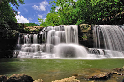
| Peters Creek Falls |
 |
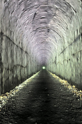
| The Tunnel |
The Tunnel
The abandoned road bed is a remnant of a twenty-eight mile stretch of railway built by the NF&G (Nicholas, Fayette and Greenbrier Railroad Company) in 1929 to 1931 to connect the towns of Swiss and Nallen. Hiking this old railroad bed is an easy way to explore and appreciate many miles of the Gauley River. Two tunnels were built for this railroad�one about a mile upstream from Carnifex Ferry near the Confluence Resort, and the other is less than half a mile from the parking area at Laurel Creek. To test your metal on this old tunnel, head west on the railroad bed. The tunnel is straight as an arrow and about 0.6 miles long. From either end you can see the proverbial �light at the end of the tunnel.� But it�s not much. Fortunately the tunnel is well-graded, and there aren�t any potholes to fall into. |
| The Light at the End of the Tunnel |
 |
| The Trestle |
The Trestle
Within just a few yards of leaving the tunnel, the rail line launches across the Gauley River along an old trestle. Technically the bridge isn�t a trestle since it is supported by a dozen or so concrete pillars some 60 feet tall. So please forgive me for taking poetic license here. Nevertheless, from the heights of the trestle, the views of the Gauley River are unsurpassed. You feel suspended above the Gauley and can savor sweeping panoramas of the river both upstream and downstream as well as Peter�s Creek, which joins the Gauley River at the northwest end of the trestle. |
| Rafters on the Gauley River |
The Waterfall
Peter�s Creek Falls (GPS: Lat. 38.231163, Long. -81.045267) are reachable from the end of the trestle if you are willing to walk 2/3 of a mile on an active railroad line. Turn right at the end of the trestle. You can�t miss the falls. They are large, a creek-wide drop of some twenty or more feet. Rocks in the creek beyond the plunge pool make access easy for photographing the falls. |
| Peters Creek Falls |
There you have it--a tunnel, a trestle, and a waterfall. As you can see there�s plenty of adventure for hikers on the Gauley River.


Comments
Post a Comment